
Thank you for supporting this site ❤️
Make a donation
Make a donation
Aljubarrota topographic map
Click on the map to display elevation.
Thank you for supporting this site ❤️
Make a donation
Make a donation
About this map
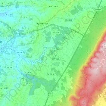
Name: Aljubarrota topographic map, elevation, terrain.
Location: Aljubarrota, Alcobasa, Leiria, Portugal (39.50138 -8.96847 39.58441 -8.86543)
Average elevation: 195 m
Minimum elevation: 20 m
Maximum elevation: 612 m
Thank you for supporting this site ❤️
Make a donation
Make a donation
Other topographic maps
Click on a map to view its topography, its elevation and its terrain.