
Coevorden topographic map
Interactive map
Click on the map to display elevation.
About this map
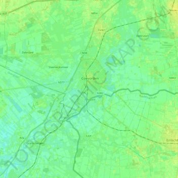
Name: Coevorden topographic map, elevation, terrain.
Location: Coevorden, Drenthe, Nederland (52.62676 6.62945 52.67856 6.86188)
Average elevation: 11 m
Minimum elevation: 5 m
Maximum elevation: 20 m
Other topographic maps
Click on a map to view its topography, its elevation and its terrain.
Steenwijksmoer
Nederland > Drenthe > Coevorden
Steenwijksmoer, Coevorden, Drenthe, Nederland, 7741 PC, Nederland
Average elevation: 11 m
Veenhuizen
Nederland > Drenthe > Coevorden > Dalen
Veenhuizen, Dalen, Coevorden, Drenthe, Nederland, 7751 SR, Nederland
Average elevation: 12 m
Oosterhesselen
Nederland > Drenthe > Coevorden
Oosterhesselen, Coevorden, Drenthe, Nederland
Average elevation: 15 m
Noord-Sleen
Nederland > Drenthe > Coevorden
Noord-Sleen, Coevorden, Drenthe, Nederland
Average elevation: 18 m
Schoonoord
Nederland > Drenthe > Coevorden
Schoonoord, Coevorden, Drenthe, Nederland
Average elevation: 19 m
't Haantje
Nederland > Drenthe > Coevorden
't Haantje, Coevorden, Drenthe, Nederland
Average elevation: 18 m
Wezuperbrug
Nederland > Drenthe > Coevorden
Wezuperbrug, Coevorden, Drenthe, Nederland
Average elevation: 20 m
De Klencke
Nederland > Drenthe > Coevorden
De Klencke, Klenkerweg, Oosterhesselen, Coevorden, Drenthe, Nederland, 7861TC, Nederland
Average elevation: 15 m