
Cass County topographic map
Interactive map
Click on the map to display elevation.
About this map
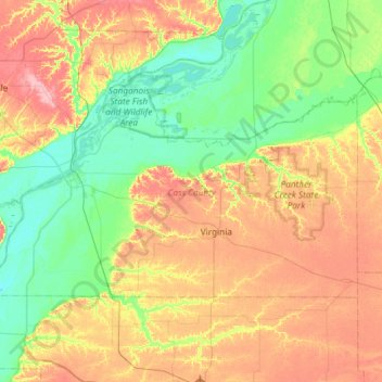
Name: Cass County topographic map, elevation, terrain.
Location: Cass County, Illinois, USA (39.87294 -90.58361 40.12445 -89.99381)
Average elevation: 167 m
Minimum elevation: 128 m
Maximum elevation: 227 m
Other topographic maps
Click on a map to view its topography, its elevation and its terrain.
Prestonfield
USA > Illinois > Prestonfield
Prestonfield, Lake County, Illinois, 60074, USA
Average elevation: 235 m
Montague Island
Montague Island, Rockford, Winnebago County, Illinois, 61104, USA
Average elevation: 254 m
Garfield Ridge
Garfield Ridge, Chicago, Cook County, Illinois, USA
Average elevation: 184 m
Mount Carmel
USA > Illinois > Mount Carmel
Mount Carmel, Wabash County, Illinois, USA
Average elevation: 128 m