
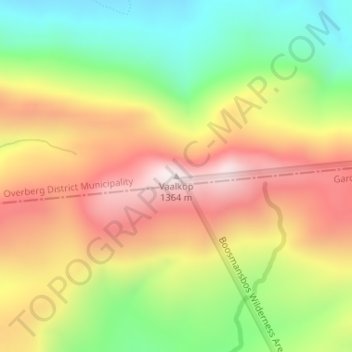
Vaalkop topographic map
Interactive map
Click on the map to display elevation.
About this map
Name: Vaalkop topographic map, elevation, terrain.
Average elevation: 994 m
Minimum elevation: 641 m
Maximum elevation: 1,354 m
Other topographic maps
Click on a map to view its topography, its elevation and its terrain.
Warmwaterberg Nature Reserve
RSA > Western Cape > Swellendam Local Municipality
Warmwaterberg Nature Reserve, Tweefontein Road, Swellendam Ward 2, Swellendam Local Municipality, Overberg District Municipality, Western Cape, RSA
Average elevation: 713 m
Doring River
RSA > Western Cape > Swellendam Local Municipality
Doring River, Swellendam Local Municipality, Overberg District Municipality, Western Cape, RSA
Average elevation: 520 m
Marloth Nature Reserve
RSA > Western Cape > Swellendam Local Municipality
Marloth Nature Reserve, Goedgeloof to Proteavallei, Langeberg Ward 7, Swellendam Local Municipality, Overberg District Municipality, Western Cape, RSA
Average elevation: 502 m