Sendai topographic map
Interactive map
Click on the map to display elevation.
About this map
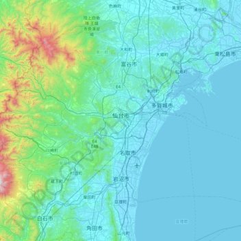
Name: Sendai topographic map, elevation, terrain.
Location: Sendai, Miyagi Prefecture, Japan (38.05085 140.46947 38.45470 141.26030)
Average elevation: 185 m
Minimum elevation: -3 m
Maximum elevation: 1,799 m
Sendai is located at lat. 38°16'05" north, long. 140°52'11" east. The city's area is 788.09 km2 (304.28 sq mi), and stretches from the Pacific Ocean to the Ōu Mountains, which are the east and west borders of Miyagi Prefecture. As a result, the city's geography is quite diverse. Eastern Sendai is a plains area, the center of the city is hilly, and western areas are mountainous. The highest point in the city is Mount Funagata which stands 1,500 metres (4,921 feet) above sea level. Unique among Japan's large coastal cities, Sendai's city core is built on a terrace at 40–60 m (131–197 ft) elevation.
Other topographic maps
Click on a map to view its topography, its elevation and its terrain.
Wadomari
Wadomari, Oshima County, Kagoshima Prefecture, Japan
Average elevation: 3 m
Mt. Nagiso
Japan > Kiso County > Nagiso
Mt. Nagiso, Nagiso, Kiso County, Nagano Prefecture, 399-5302, Japan
Average elevation: 1,258 m
Yusuhara
Japan > Takaoka County > Yusuhara
Yusuhara, Takaoka County, Kochi Prefecture, Japan
Average elevation: 662 m
Nagano
Japan > Chubu Region > Nagano
Nagano, Nagano Prefecture, Chubu Region, 380-8512, Japan
Average elevation: 761 m
Ebetsu
Ebetsu, Ishikari Subprefecture, Hokkaidō Prefecture, Hokkaidō Region, Japan
Average elevation: 14 m
Shibetsu
Shibetsu, Nemuro Subprefecture, Hokkaidō Prefecture, Hokkaidō Region, 086-1632, Japan
Average elevation: 105 m
由比ガ浜3
Japan > Kanagawa Prefecture > Kamakura > 由比ガ浜3
由比ガ浜3, Kamakura, Kanagawa Prefecture, Kanto, 248-0014, Japan
Average elevation: 28 m
6th station
Japan > Tochigi Prefecture > Nikkō > Nikko
6th station, Nikkō, Nikko, Tochigi Prefecture, Kanto, 321-1661, Japan
Average elevation: 1,973 m
湊入船町
Japan > Chubu Region > Toyama > 湊入船町
湊入船町, Toyama, Toyama Prefecture, Chubu Region, 930-0001, Japan
Average elevation: 13 m
Karuizawa
Japan > Chubu Region > Karuizawa
Karuizawa, Kitasaku County, Nagano Prefecture, Chubu Region, 389-0102, Japan
Average elevation: 1,018 m
Kyoto Prefecture
Japan > Kinki Region > Kyotanba
Kyoto Prefecture, 綾部宮島線, Kyotanba, Funai County, Kyoto Prefecture, Kinki Region, Japan
Average elevation: 453 m
Shikoku
Japan > Shikoku Region > Hidaka
Shikoku, Hidaka, Takaoka County, Kochi Prefecture, Shikoku Region, Japan
Average elevation: 156 m
Mt. Tsurugi
Japan > Shikoku Region > Naka
Mt. Tsurugi, Naka, Naka County, Tokushima Prefecture, Shikoku Region, 779-4306, Japan
Average elevation: 1,584 m