
Make a donation
Iruma County topographic map
Click on the map to display elevation.
Make a donation
About this map
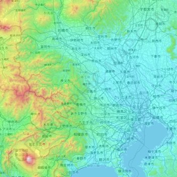
Name: Iruma County topographic map, elevation, terrain.
Location: Iruma County, Saitama Prefecture, Japan (35.22307 138.61380 36.62307 140.01380)
Average elevation: 397 m
Minimum elevation: -3 m
Maximum elevation: 3,700 m
Make a donation
Other topographic maps
Click on a map to view its topography, its elevation and its terrain.
Make a donation
Sapporo
Sapporo is a city located in the southwest part of Ishikari Plain and the alluvial fan of the Toyohira River, a tributary stream of the Ishikari River. It is part of Ishikari Subprefecture. Roadways in the urban district are laid to make a grid plan. The western and southern parts of Sapporo are occupied by a…
Average elevation: 273 m
Make a donation
Sendai
Sendai is located at lat. 38°16'05" north, long. 140°52'11" east. The city's area is 788.09 km2 (304.28 sq mi), and stretches from the Pacific Ocean to the Ōu Mountains, which are the east and west borders of Miyagi Prefecture. As a result, the city's geography is quite diverse. Eastern Sendai is a plains…
Average elevation: 185 m
Make a donation
Make a donation
Hokkaido Prefecture
As Japan's coldest region, Hokkaidō has relatively cool summers and icy/snowy winters. Most of the island falls in the humid continental climate zone with Köppen climate classification Dfb (hemiboreal) in most areas but Dfa (hot summer humid continental) in some inland lowlands. The average August…
Average elevation: 81 m
Make a donation
Make a donation