
Le Vailloud topographic map
Interactive map
Click on the map to display elevation.
About this map
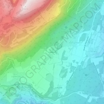
Name: Le Vailloud topographic map, elevation, terrain.
Average elevation: 849 m
Minimum elevation: 569 m
Maximum elevation: 1,547 m
Other topographic maps
Click on a map to view its topography, its elevation and its terrain.
Refuge du Chauderon
Suisse > Vaud > District du Jura-Nord vaudois > L'Abergement > Le Vailloud
Refuge du Chauderon, Crêt des Bordes, Le Vailloud, L'Abergement, District du Jura-Nord vaudois, Vaud, 1355, Suisse
Average elevation: 863 m