
Thank you for supporting this site ❤️
Make a donation
Make a donation
Gullringen topographic map
Click on the map to display elevation.
Thank you for supporting this site ❤️
Make a donation
Make a donation
About this map
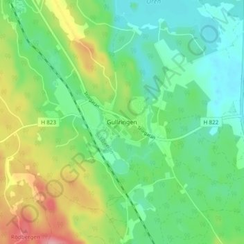
Name: Gullringen topographic map, elevation, terrain.
Location: Gullringen, Vimmerby kommun, Kalmar County, 590 81, Sweden (57.78006 15.69728 57.82006 15.73728)
Average elevation: 140 m
Minimum elevation: 101 m
Maximum elevation: 217 m
Thank you for supporting this site ❤️
Make a donation
Make a donation
Other topographic maps
Click on a map to view its topography, its elevation and its terrain.
Thank you for supporting this site ❤️
Make a donation
Make a donation
Thank you for supporting this site ❤️
Make a donation
Make a donation