
Make a donation
Arusha topographic map
Click on the map to display elevation.
Make a donation
Arusha
Despite its proximity to the equator, Arusha's elevation of 1,400 metres (4,600 ft) on the southern slopes of Mount Meru keeps temperatures relatively low and alleviates humidity. Cool dry air is prevalent for much of the year. The temperature typically ranges between 10 and 30 °C (50 and 86 °F) with an average annual high temperature around 25 °C or 77 °F. It has distinct wet and dry seasons, and experiences an eastern prevailing wind from the Indian Ocean, a few hundred kilometres east. Under the Köppen climate classification system, it has a subtropical highland climate (Cwb). Areas away from Arusha to the south and west are classified as tropical savanna climate (Aw).
Make a donation
About this map
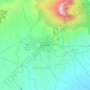
Name: Arusha topographic map, elevation, terrain.
Average elevation: 1,572 m
Minimum elevation: 966 m
Maximum elevation: 4,530 m
Make a donation
Other topographic maps
Click on a map to view its topography, its elevation and its terrain.