
Thank you for supporting this site ❤️
Make a donation
Make a donation
Opole Voivodeship topographic map
Click on the map to display elevation.
Thank you for supporting this site ❤️
Make a donation
Make a donation
About this map
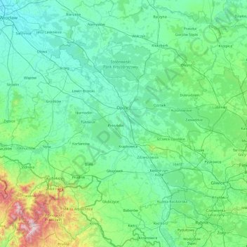
Name: Opole Voivodeship topographic map, elevation, terrain.
Location: Opole Voivodeship, Poland (49.97249 16.90790 51.19463 18.69549)
Average elevation: 254 m
Minimum elevation: 110 m
Maximum elevation: 1,466 m
Thank you for supporting this site ❤️
Make a donation
Make a donation
Other topographic maps
Click on a map to view its topography, its elevation and its terrain.
Thank you for supporting this site ❤️
Make a donation
Make a donation
Thank you for supporting this site ❤️
Make a donation
Make a donation
Wilcza Góra
Poland > West Pomeranian Voivodeship > Szczecinek County > Wierzchowo
Average elevation: 152 m