
Thank you for supporting this site ❤️
Make a donation
Make a donation
Glen topographic map
Click on the map to display elevation.
Thank you for supporting this site ❤️
Make a donation
Make a donation
About this map
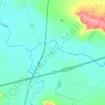
Name: Glen topographic map, elevation, terrain.
Average elevation: 1,301 m
Minimum elevation: 1,276 m
Maximum elevation: 1,385 m
Thank you for supporting this site ❤️
Make a donation
Make a donation
Other topographic maps
Click on a map to view its topography, its elevation and its terrain.
Mangaung Ward 26
South Africa > Free State > Mangaung Metropolitan Municipality
Average elevation: 1,338 m
Rustfontein Dam
South Africa > Free State > Mangaung Metropolitan Municipality
Average elevation: 1,375 m
Bloemspruit
South Africa > Free State > Mangaung Metropolitan Municipality > Bloemfontein
Average elevation: 1,376 m
Wag-n'-Bietjie Park
South Africa > Free State > Mangaung Metropolitan Municipality > Bloemfontein
Average elevation: 1,411 m
Thank you for supporting this site ❤️
Make a donation
Make a donation