
Thank you for supporting this site ❤️
Make a donation
Make a donation
Horstmar topographic map
Click on the map to display elevation.
Thank you for supporting this site ❤️
Make a donation
Make a donation
About this map
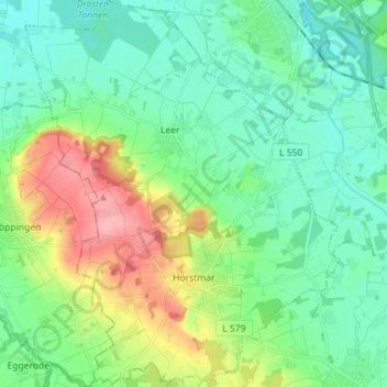
Name: Horstmar topographic map, elevation, terrain.
Location: Horstmar, Kreis Steinfurt, Noordrijn-Westfalen, 48612, Duitsland (52.05653 7.24179 52.14347 7.35663)
Average elevation: 84 m
Minimum elevation: 54 m
Maximum elevation: 160 m
Thank you for supporting this site ❤️
Make a donation
Make a donation
Other topographic maps
Click on a map to view its topography, its elevation and its terrain.
Isendorf-Beckwermert
Duitsland > Noordrijn-Westfalen > Kreis Steinfurt > Emsdetten
Average elevation: 42 m
Leeden
Duitsland > Noordrijn-Westfalen > Kreis Steinfurt > Tecklenburg > Leeden
Average elevation: 104 m
Thank you for supporting this site ❤️
Make a donation
Make a donation