
Thank you for supporting this site ❤️
Make a donation
Make a donation
La Paloma topographic map
Click on the map to display elevation.
Thank you for supporting this site ❤️
Make a donation
Make a donation
About this map
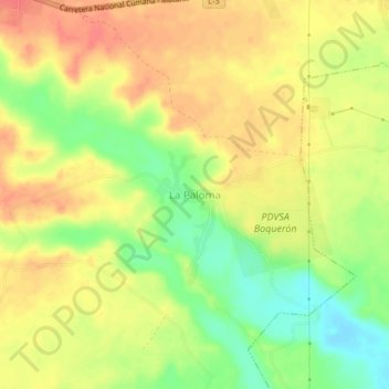
Name: La Paloma topographic map, elevation, terrain.
Average elevation: 82 m
Minimum elevation: 50 m
Maximum elevation: 105 m
Thank you for supporting this site ❤️
Make a donation
Make a donation
Other topographic maps
Click on a map to view its topography, its elevation and its terrain.
Maturin
Venezuela > Monagas State > Municipio Maturín
Maturin is located at 67 meters of altitude and 520 kilometres from the country's capital, Caracas. It is right next to the Guarapiche River and is a crossroad for roads towards the center, the Caribbean coast and the Orinoco River
Average elevation: 58 m