Geolocate

Middleburg topographic map

Interactive map

Click on the map to display elevation.

About this map

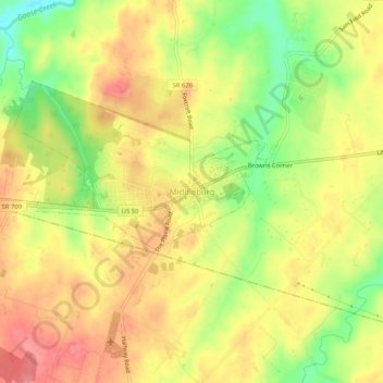
Name: Middleburg topographic map, elevation, terrain.

Location: Middleburg, Loudoun County, Virginia, 20117, United States (38.94902 -77.75551 38.98902 -77.71551)

Average elevation: 144 m

Minimum elevation: 96 m

Maximum elevation: 178 m

According to the United States Census Bureau, the town has a total area of 0.6 square mile (1.5 km2), all land. The elevation is 486 feet.

Wikipedia (CC-BY-SA 3.0)

Other topographic maps

Click on a map to view its topography, its elevation and its terrain.

Stone Ridge

United States > Virginia > Loudoun County

Stone Ridge, Loudoun County, Virginia, 20105, United States

Average elevation: 103 m

Middleburg

United States > Virginia > Loudoun County

Middleburg, Loudoun County, Virginia, United States

Average elevation: 143 m

Cascades

United States > Virginia > Loudoun County

Cascades, Loudoun County, Virginia, 20165, United States

Average elevation: 81 m