
North Kivu topographic map
Interactive map
Click on the map to display elevation.
About this map
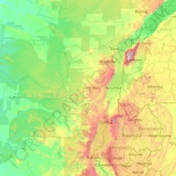
Name: North Kivu topographic map, elevation, terrain.
Location: North Kivu, Democratic Republic of the Congo (-3.12456 26.14619 1.99544 31.26619)
Average elevation: 1,069 m
Minimum elevation: 447 m
Maximum elevation: 4,919 m
Other topographic maps
Click on a map to view its topography, its elevation and its terrain.
Goma
Democratic Republic of the Congo > North Kivu > Goma > Goma
Goma, Mabanga Nord, Karisimbi, Goma, North Kivu, 841, Democratic Republic of the Congo
Average elevation: 1,740 m
river
Democratic Republic of the Congo > North Kivu
river, Bahunde, Masisi, North Kivu, Democratic Republic of the Congo
Average elevation: 1,824 m
Mabangwa II
Democratic Republic of the Congo > North Kivu > Beni > Mabangwa II
Mabangwa II, Beni, Bungulu, Beni, North Kivu, Democratic Republic of the Congo
Average elevation: 1,167 m