
Les Gillis topographic map
Interactive map
Click on the map to display elevation.
About this map
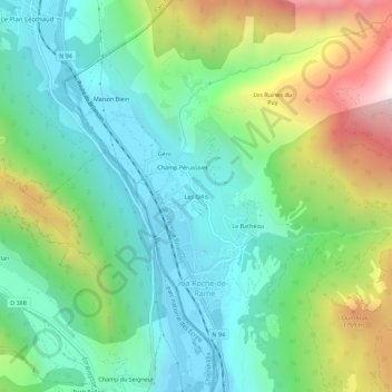
Name: Les Gillis topographic map, elevation, terrain.
Average elevation: 1,296 m
Minimum elevation: 925 m
Maximum elevation: 2,125 m
Other topographic maps
Click on a map to view its topography, its elevation and its terrain.
Pra Reboul
France > Provence-Alpes-Côte d'Azur > Hautes-Alpes > La Roche-de-Rame
Pra Reboul, La Roche-de-Rame, Briançon, Hautes-Alpes, Provence-Alpes-Côte d'Azur, France métropolitaine, 05310, France
Average elevation: 1,204 m
Le Bathéou
France > Provence-Alpes-Côte d'Azur > Hautes-Alpes > La Roche-de-Rame
Le Bathéou, La Roche-de-Rame, Briançon, Hautes-Alpes, Provence-Alpes-Côte d'Azur, France métropolitaine, 05310, France
Average elevation: 1,353 m
Bel Pinet
France > Provence-Alpes-Côte d'Azur > Hautes-Alpes > La Roche-de-Rame
Bel Pinet, La Roche-de-Rame, Briançon, Hautes-Alpes, Provence-Alpes-Côte d'Azur, France métropolitaine, 05310, France
Average elevation: 1,487 m
Plan de la Loubiere
France > Provence-Alpes-Côte d'Azur > Hautes-Alpes > La Roche-de-Rame
Plan de la Loubiere, Le Lauzet, La Roche-de-Rame, Briançon, Hautes-Alpes, Provence-Alpes-Côte d'Azur, France métropolitaine, 05310, France
Average elevation: 2,056 m