
Hirschberg topographic map
Interactive map
Click on the map to display elevation.
About this map
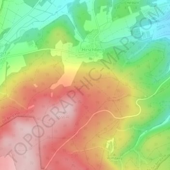
Name: Hirschberg topographic map, elevation, terrain.
Location: Hirschberg, Herborn, Lahn-Dill-Kreis, Hessen, Deutschland (50.63079 8.25447 50.65899 8.28289)
Average elevation: 400 m
Minimum elevation: 260 m
Maximum elevation: 534 m
Other topographic maps
Click on a map to view its topography, its elevation and its terrain.
Herborn
Deutschland > Hessen > Lahn-Dill-Kreis > Herborn > Herborn
Herborn, Lahn-Dill-Kreis, Hessen, 35745, Deutschland
Average elevation: 303 m