
Attendorn topographic map
Interactive map
Click on the map to display elevation.
About this map
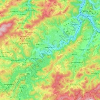
Name: Attendorn topographic map, elevation, terrain.
Location: Attendorn, Kreis Olpe, Nordrhein-Westfalen, 57439, Deutschland (51.07271 7.79579 51.17069 8.00401)
Average elevation: 384 m
Minimum elevation: 229 m
Maximum elevation: 630 m
Charakteristisch für Attendorn ist der große Höhenunterschied von fast 400 Metern, der im Stadtgebiet vorherrscht. Das Zentrum der Stadt Attendorn liegt in einem Talkessel des Biggetals, hat sich aber mittlerweile auch auf die Hügel um die Stadt herum ausgedehnt. Diese Lage wirkt sich auf das Klima aus und führt zu lokal unterschiedlichen Temperaturen.
Other topographic maps
Click on a map to view its topography, its elevation and its terrain.
Saßmicke
Deutschland > Nordrhein-Westfalen > Kreis Olpe > Olpe
Saßmicke, Olpe, Kreis Olpe, Nordrhein-Westfalen, 57462, Deutschland
Average elevation: 387 m
Nuttmecke
Deutschland > Nordrhein-Westfalen > Kreis Olpe > Attendorn > Lichtringhausen
Nuttmecke, Lichtringhausen, Attendorn, Kreis Olpe, Nordrhein-Westfalen, Deutschland
Average elevation: 411 m
Grevenbrück
Deutschland > Nordrhein-Westfalen > Kreis Olpe > Lennestadt
Grevenbrück, Lennestadt, Kreis Olpe, Nordrhein-Westfalen, Deutschland
Average elevation: 309 m
Hoffnung
Deutschland > Nordrhein-Westfalen > Kreis Olpe > Wenden > Rothemühle
Hoffnung, Rothemühle, Wenden, Kreis Olpe, Nordrhein-Westfalen, 57482, Deutschland
Average elevation: 397 m
Höchsten
Deutschland > Nordrhein-Westfalen > Kreis Olpe > Olpe
Höchsten, Olpe, Kreis Olpe, Nordrhein-Westfalen, 57462, Deutschland
Average elevation: 431 m
Sondern
Deutschland > Nordrhein-Westfalen > Kreis Olpe > Olpe
Sondern, Olpe, Kreis Olpe, Nordrhein-Westfalen, 57462, Deutschland
Average elevation: 352 m
Olpe
Deutschland > Nordrhein-Westfalen > Kreis Olpe
Olpe, Kreis Olpe, Nordrhein-Westfalen, 57462, Deutschland
Average elevation: 400 m
Rönkhausen
Deutschland > Nordrhein-Westfalen > Kreis Olpe > Finnentrop
Rönkhausen, Finnentrop, Kreis Olpe, Nordrhein-Westfalen, 57413, Deutschland
Average elevation: 359 m