
Geislautern topographic map
Interactive map
Click on the map to display elevation.
About this map
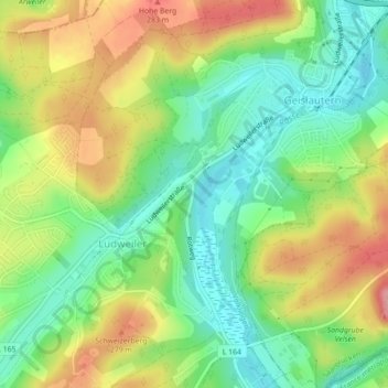
Name: Geislautern topographic map, elevation, terrain.
Average elevation: 231 m
Minimum elevation: 180 m
Maximum elevation: 300 m
Fenne | Fürstenhausen | Geislautern | Heidstock | Lauterbach | Ludweiler | Luisenthal | Röchlinghöhe | Völklingen | Wehrden
Other topographic maps
Click on a map to view its topography, its elevation and its terrain.
Fürstenhausen
Deutschland > Saarland > Regionalverband Saarbrücken > Völklingen
Fürstenhausen, Völklingen, Regionalverband Saarbrücken, Saarland, Deutschland
Average elevation: 229 m