
Tarutung topographic map
Interactive map
Click on the map to display elevation.
About this map
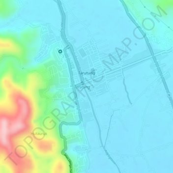
Name: Tarutung topographic map, elevation, terrain.
Average elevation: 980 m
Minimum elevation: 942 m
Maximum elevation: 1,136 m
Other topographic maps
Click on a map to view its topography, its elevation and its terrain.
Si Raja Hutagalung
Indonesia > North Sumatra > North Tapanuli
Si Raja Hutagalung, North Tapanuli, North Sumatra, Sumatra, Indonesia
Average elevation: 1,113 m
Aqua Soda- natural sparkling water pool
Indonesia > North Sumatra > North Tapanuli > Tarutung
Aqua Soda- natural sparkling water pool, Jalan Sibolga–Tarutung, Tarutung, North Tapanuli, North Sumatra, 22411, Indonesia
Average elevation: 1,015 m