
Bothwell topographic map
Interactive map
Click on the map to display elevation.
About this map
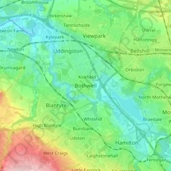
Name: Bothwell topographic map, elevation, terrain.
Location: Bothwell, South Lanarkshire, Scotland, G71 8RB, United Kingdom (55.76266 -4.10770 55.84266 -4.02770)
Average elevation: 65 m
Minimum elevation: 10 m
Maximum elevation: 209 m
Other topographic maps
Click on a map to view its topography, its elevation and its terrain.
Larkhall
United Kingdom > Scotland > South Lanarkshire
Larkhall, South Lanarkshire, Scotland, ML9 1DR, United Kingdom
Average elevation: 114 m
Biggar
United Kingdom > Scotland > South Lanarkshire
Biggar, South Lanarkshire, Scotland, ML12 6AE, United Kingdom
Average elevation: 254 m
East Kilbride
United Kingdom > Scotland > South Lanarkshire
East Kilbride, South Lanarkshire, Scotland, G74 1JT, United Kingdom
Average elevation: 175 m
Lanark
United Kingdom > Scotland > South Lanarkshire
Lanark, South Lanarkshire, Scotland, ML11 7EX, United Kingdom
Average elevation: 206 m