
Vallée de Zermatt topographic map
Interactive map
Click on the map to display elevation.
About this map
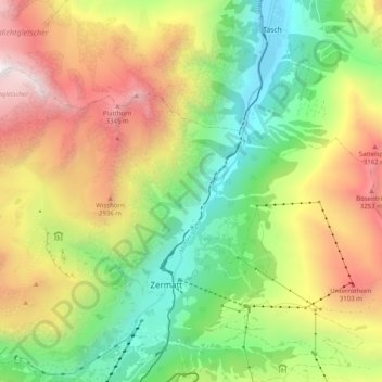
Name: Vallée de Zermatt topographic map, elevation, terrain.
Location: Vallée de Zermatt, Zermatt, Viège, Valais, 3920, Suisse (46.00361 7.73359 46.07296 7.77723)
Average elevation: 2,368 m
Minimum elevation: 1,432 m
Maximum elevation: 3,639 m
Other topographic maps
Click on a map to view its topography, its elevation and its terrain.
Schwarzsee
Suisse > Valais > Viège > Zermatt > Schwarzsee
Schwarzsee, Zermatt, Viège, Valais, 3920, Suisse
Average elevation: 2,499 m
Pointe Dufour
Suisse > Valais > Viège > Zermatt
Pointe Dufour, Zermatt, Viège, Valais, 3920, Suisse
Average elevation: 4,033 m