
Kandashin topographic map
Interactive map
Click on the map to display elevation.
About this map
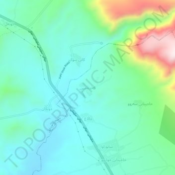
Name: Kandashin topographic map, elevation, terrain.
Average elevation: 828 m
Minimum elevation: 688 m
Maximum elevation: 1,281 m
Other topographic maps
Click on a map to view its topography, its elevation and its terrain.
Qada Raniyah
Iraq > Sulaymaniyah Governorate
Qada Raniyah, Chwar Qurna Subdistrict, Ranya District, Sulaymaniyah Governorate, Iraqi Kurdistan Region, Iraq
Average elevation: 1,075 m