
Thank you for supporting this site ❤️
Make a donation
Make a donation
Phillip Peak topographic map
Click on the map to display elevation.
Thank you for supporting this site ❤️
Make a donation
Make a donation
About this map
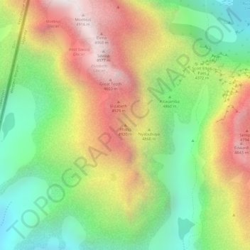
Name: Phillip Peak topographic map, elevation, terrain.
Location: Phillip Peak, Kasese, Western Region, Uganda (0.36372 29.88027 0.36382 29.88037)
Average elevation: 4,353 m
Minimum elevation: 3,870 m
Maximum elevation: 4,878 m
Thank you for supporting this site ❤️
Make a donation
Make a donation