
Make a donation
Petershagen topographic map
Click on the map to display elevation.
Make a donation
About this map
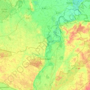
Name: Petershagen topographic map, elevation, terrain.
Average elevation: 48 m
Minimum elevation: 24 m
Maximum elevation: 84 m
Make a donation
Other topographic maps
Click on a map to view its topography, its elevation and its terrain.
Reineberg
Germany > North Rhine-Westphalia > Kreis Minden-Lübbecke > Lübbecke
The Reineberg is a hill on the Wiehen ridge, south of the town of Lübbecke. With a height of 275.9 m above sea level it is, from a topographical point of view, not a particularly impressive eminence in this part of the Wiehen Hills, because, in the immediate vicinity are considerably higher summits, such as…
Average elevation: 181 m
Heimsen
Germany > North Rhine-Westphalia > Kreis Minden-Lübbecke > Petershagen
Average elevation: 41 m
Hüllhorst
Germany > North Rhine-Westphalia > Kreis Minden-Lübbecke > Hüllhorst > Hüllhorst
Average elevation: 120 m
Lübbecke
Germany > North Rhine-Westphalia > Kreis Minden-Lübbecke > Lübbecke > Lübbecke
Average elevation: 110 m
Make a donation