
Sidney topographic map
Interactive map
Click on the map to display elevation.
About this map
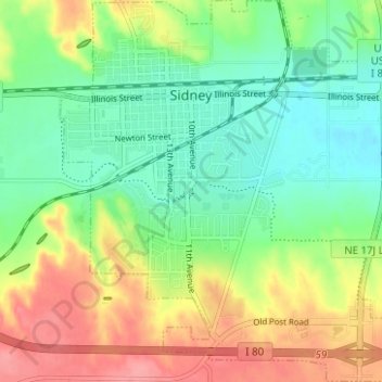
Name: Sidney topographic map, elevation, terrain.
Location: Sidney, Cheyenne County, Nebraska, 69162, United States (41.10955 -102.99822 41.15651 -102.94058)
Average elevation: 1,268 m
Minimum elevation: 1,235 m
Maximum elevation: 1,317 m
Other topographic maps
Click on a map to view its topography, its elevation and its terrain.
Potter
United States > Nebraska > Cheyenne County
Potter, Cheyenne County, Nebraska, United States
Average elevation: 1,350 m
Lorenzo
United States > Nebraska > Cheyenne County
Lorenzo, Cheyenne County, Nebraska, United States
Average elevation: 1,334 m
Dalton
United States > Nebraska > Cheyenne County > Dalton
Dalton, Cheyenne County, Nebraska, 69131, United States
Average elevation: 1,300 m