
Erlau topographic map
Interactive map
Click on the map to display elevation.
About this map
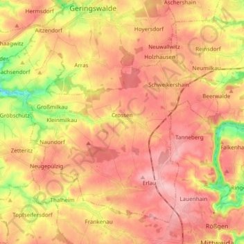
Name: Erlau topographic map, elevation, terrain.
Location: Erlau, Mittelsachsen, Sachsen, Deutschland (50.99332 12.83772 51.07074 12.98720)
Average elevation: 274 m
Minimum elevation: 194 m
Maximum elevation: 322 m
In Erlau befindet sich seit 2012 eine Windkraftanlage Enercon E-101 mit 135 m Nabenhöhe. Sie ist die höchste Windkraftanlage in Sachsen.
Other topographic maps
Click on a map to view its topography, its elevation and its terrain.
09629
Deutschland > Sachsen > Mittelsachsen > Neukirchen
09629, Neukirchen, Reinsberg, Mittelsachsen, Sachsen, Deutschland
Average elevation: 324 m