
Cleo Springs topographic map
Interactive map
Click on the map to display elevation.
About this map
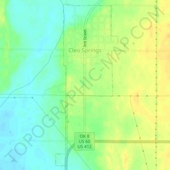
Name: Cleo Springs topographic map, elevation, terrain.
Location: Cleo Springs, Major County, Oklahoma, 73729, United States (36.38693 -98.44643 36.41257 -98.43284)
Average elevation: 387 m
Minimum elevation: 374 m
Maximum elevation: 400 m
Other topographic maps
Click on a map to view its topography, its elevation and its terrain.
Orienta
United States > Oklahoma > Major County
Orienta, Major County, Oklahoma, United States
Average elevation: 380 m
Fairview
United States > Oklahoma > Major County > Fairview
Fairview, Major County, Oklahoma, 73737, United States
Average elevation: 398 m
Ames
United States > Oklahoma > Major County
Ames, Major County, Oklahoma, 73718, United States
Average elevation: 369 m