
Make a donation
Elsen topographic map
Click on the map to display elevation.
Make a donation
Elsen
Die katholische Pfarrkirche St. Dionysius und St. Urban liegt auf einer kleinen Anhöhe und beherrscht das Elsener Ortsbild. Der massige, fünfgeschossige, romanische Turm aus dem 11./12. Jahrhundert überragt heute wie damals alle anderen Gebäude des Ortes. Die Kirche war lange Zeit auch Mutterkirche der Gemeinden Neuhaus und Sande.
Make a donation
About this map
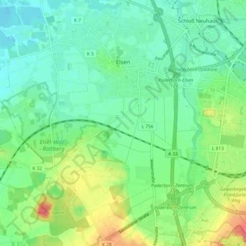
Name: Elsen topographic map, elevation, terrain.
Average elevation: 113 m
Minimum elevation: 93 m
Maximum elevation: 155 m
Make a donation
Other topographic maps
Click on a map to view its topography, its elevation and its terrain.
Barkhausen
Deutschland > Nordrhein-Westfalen > Kreis Paderborn > Paderborn > Wewer
Average elevation: 139 m
Tallesee Mittelsee
Deutschland > Nordrhein-Westfalen > Kreis Paderborn > Paderborn
Average elevation: 118 m
Make a donation
Nesthauser See
Deutschland > Nordrhein-Westfalen > Kreis Paderborn > Paderborn > Sande
Average elevation: 101 m
Habichtsee
Deutschland > Nordrhein-Westfalen > Kreis Paderborn > Paderborn > Sennelager
Average elevation: 112 m