
Alì topographic map
Interactive map
Click on the map to display elevation.
About this map
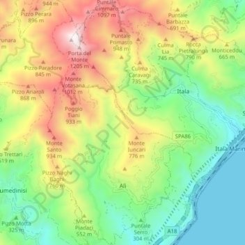
Name: Alì topographic map, elevation, terrain.
Location: Alì, Messine, Sicile, 98020, Italie (38.01245 15.36646 38.07379 15.43598)
Average elevation: 487 m
Minimum elevation: -1 m
Maximum elevation: 1,246 m
Other topographic maps
Click on a map to view its topography, its elevation and its terrain.
Vulcano Porto
Italie > Sicile > Messine > Lipari > Vulcano Porto
Vulcano Porto, Lipari, Messine, Sicile, 98050, Italie
Average elevation: 50 m