
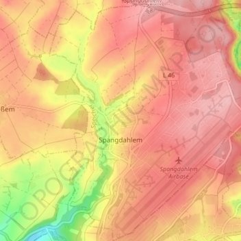
Spangdahlem topographic map
Interactive map
Click on the map to display elevation.
About this map
Name: Spangdahlem topographic map, elevation, terrain.
Average elevation: 333 m
Minimum elevation: 229 m
Maximum elevation: 383 m
Other topographic maps
Click on a map to view its topography, its elevation and its terrain.
Preischeid
Germany > Rhineland-Palatinate > Eifelkreis Bitburg-Prüm
Preischeid, Arzfeld, Eifelkreis Bitburg-Prüm, Rhineland-Palatinate, Germany
Average elevation: 375 m
Bollendorf
Germany > Rhineland-Palatinate > Eifelkreis Bitburg-Prüm > Bollendorf
Bollendorf, Südeifel, Eifelkreis Bitburg-Prüm, Rhineland-Palatinate, 54669, Germany
Average elevation: 311 m
Herforst
Germany > Rhineland-Palatinate > Eifelkreis Bitburg-Prüm > Herforst
Herforst, Speicher, Eifelkreis Bitburg-Prüm, Rhineland-Palatinate, Germany
Average elevation: 340 m
Alsdorf
Germany > Rhineland-Palatinate > Eifelkreis Bitburg-Prüm > Alsdorf
Alsdorf, Südeifel, Eifelkreis Bitburg-Prüm, Rhineland-Palatinate, Germany
Average elevation: 284 m
Auw bei Prüm
Germany > Rhineland-Palatinate > Eifelkreis Bitburg-Prüm > Auw bei Prüm
Auw bei Prüm, Prüm, Eifelkreis Bitburg-Prüm, Rhineland-Palatinate, Germany
Average elevation: 552 m