
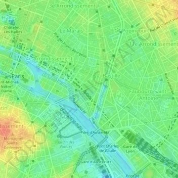
Quartier de l'Arsenal topographic map
Interactive map
Click on the map to display elevation.
About this map
Name: Quartier de l'Arsenal topographic map, elevation, terrain.
Average elevation: 46 m
Minimum elevation: 27 m
Maximum elevation: 73 m
Other topographic maps
Click on a map to view its topography, its elevation and its terrain.
Picpus
France > Ile-de-France > Paris
Picpus, 12th Arrondissement, Paris, Ile-de-France, Metropolitan France, 75012, France
Average elevation: 58 m
Croulebarbe
France > Ile-de-France > Paris
Croulebarbe, 13th Arrondissement, Paris, Ile-de-France, Metropolitan France, 75013, France
Average elevation: 58 m
Enfants Rouges
France > Ile-de-France > Paris
Enfants Rouges, 3rd Arrondissement, Paris, Ile-de-France, Metropolitan France, 75003, France
Average elevation: 51 m
Enjöy
France > Ile-de-France > Paris
Enjöy, Passage du Havre, Chaussée-d'Antin, 9th Arrondissement, Paris, Ile-de-France, Metropolitan France, 75009, France
Average elevation: 56 m
16th Arrondissement
France > Ile-de-France > Paris
16th Arrondissement, Paris, Ile-de-France, Metropolitan France, France
Average elevation: 45 m
Square René Le Gall
France > Ile-de-France > Paris
Square René Le Gall, Croulebarbe, 13th Arrondissement, Paris, Ile-de-France, Metropolitan France, 75013, France
Average elevation: 57 m