
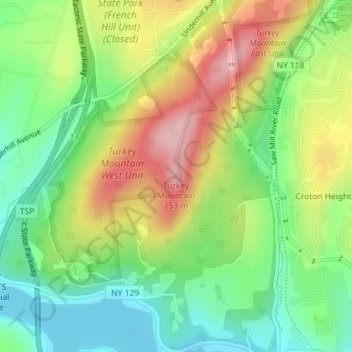
Turkey Mountain topographic map
Interactive map
Click on the map to display elevation.
About this map
Name: Turkey Mountain topographic map, elevation, terrain.
Average elevation: 142 m
Minimum elevation: 64 m
Maximum elevation: 249 m
Other topographic maps
Click on a map to view its topography, its elevation and its terrain.
Clarence Town
United States of America > New York
Clarence Town, Erie, New York, United States of America
Average elevation: 194 m
Town of Ramapo
United States of America > New York
Town of Ramapo, Rockland County, New York, United States of America
Average elevation: 173 m
Staten Island
United States of America > New York
Staten Island, Richmond County, New York, United States of America
Average elevation: 11 m
Ithaca
United States of America > New York > Ithaca
Ithaca, Ithaca Town, New York, United States of America
Average elevation: 194 m
Oak Beach
United States of America > New York > Oak Beach
Oak Beach, Suffolk, New York, United States of America
Average elevation: 1 m
Erin
United States of America > New York > Erin
Erin, Chemung, New York, 14838, United States of America
Average elevation: 448 m
East Norwich
United States of America > New York > East Norwich
East Norwich, Nassau, New York, 11732, United States of America
Average elevation: 60 m
Pelham
United States of America > New York > Pelham
Pelham, Westchester, New York, 10803, United States of America
Average elevation: 30 m
Burleigh Hill
United States of America > New York
Burleigh Hill, Genesee County, New York, 14525, United States of America
Average elevation: 317 m
Gothicville
United States of America > New York > Town of Decatur > Gothicville
Gothicville, Town of Decatur, Otsego County, New York, United States of America
Average elevation: 615 m
Mount Irvine
United States of America > New York
Mount Irvine, Cattaraugus County, New York, United States of America
Average elevation: 576 m
Murray Hill
United States of America > New York > Scarsdale > Murray Hill
Murray Hill, Scarsdale, Westchester, New York, 10583, United States of America
Average elevation: 79 m
Waterford Park
United States of America > New York
Waterford Park, Grand Island, Erie, New York, 14072, United States of America
Average elevation: 179 m
Olivebridge
United States of America > New York > Olivebridge
Olivebridge, Town of Olive, Ulster, New York, 12461, United States of America
Average elevation: 189 m
Green's Creek
United States of America > New York
Green's Creek, West Sayville, Suffolk, New York, 11796, United States of America
Average elevation: 3 m
Wave Hill
United States of America > New York > New York
Wave Hill, Riverdale, New York, The Bronx, Bronx County, New York, United States of America
Average elevation: 25 m
Steele Creek
United States of America > New York > Ilion
Steele Creek, Ilion, Town of German Flatts, Herkimer County, New York, 13357, United States of America
Average elevation: 153 m
Thistle Island
United States of America > New York
Thistle Island, Town of Webb, Herkimer County, New York, United States of America
Average elevation: 572 m
Victoria
United States of America > New York > Victoria
Victoria, Chautauqua County, New York, 14785, United States of America
Average elevation: 425 m
Paradise Beach
United States of America > New York > Paradise Beach
Paradise Beach, Warren County, New York, 12804, United States of America
Average elevation: 132 m
Shirley
United States of America > New York > Shirley
Shirley, Suffolk, New York, 11967, United States of America
Average elevation: 12 m
Sperryville
United States of America > New York > Sperryville
Sperryville, Lewis County, New York, United States of America
Average elevation: 376 m
Long Flat
United States of America > New York > Long Flat
Long Flat, Town of Hancock, Delaware County, New York, 13756, United States of America
Average elevation: 501 m
Bitch Mountain
United States of America > New York
Bitch Mountain, Essex County, New York, United States of America
Average elevation: 579 m
Holtsville
United States of America > New York > Holtsville
Holtsville, Suffolk, New York, 11742, United States of America
Average elevation: 32 m
Coopersville
United States of America > New York > Coopersville
Coopersville, Clinton County, New York, 12919, United States of America
Average elevation: 39 m
Hunts Creek
United States of America > New York > Marathon
Hunts Creek, Marathon, Marathon Town, Cortland County, New York, 13803, United States of America
Average elevation: 361 m
WNYC-AM (New York)
United States of America > New York > New York
WNYC-AM (New York), 8, Greenpoint Avenue, Greenpoint, New York, Brooklyn, Kings County, New York, 11222, United States of America
Average elevation: 4 m
Tooker Mountain
United States of America > New York
Tooker Mountain, Town of Webb, Herkimer County, New York, United States of America
Average elevation: 533 m
Parkers
United States of America > New York > Parkers
Parkers, Lewis County, New York, United States of America
Average elevation: 566 m
Sandy Creek
United States of America > New York > Sandy Creek
Sandy Creek, Town of Sandy Creek, Oswego County, New York, United States of America
Average elevation: 152 m
Manhattan Island
United States of America > New York > Alexandria Bay
Manhattan Island, Alexandria Bay, Jefferson County, New York, United States of America
Average elevation: 77 m
Hawks Nest
United States of America > New York
Hawks Nest, Town of Fremont, Sullivan County, New York, 12760, United States of America
Average elevation: 445 m
Liggett Terrace
United States of America > New York > New York > Liggett Terrace
Liggett Terrace, Manhattan Community Board 1, Manhattan, New York County, New York, 10004, United States of America
Average elevation: 3 m
Macedon
United States of America > New York > Macedon
Macedon, Macedon Town, Wayne County, New York, United States of America
Average elevation: 152 m
Washington County
United States of America > New York
Kingsbury, Washington County, New York, 12839, United States of America
Average elevation: 77 m
Wayville
United States of America > New York > Wayville
Wayville, Town of Stillwater, Saratoga County, New York, United States of America
Average elevation: 114 m
Briarcliff Manor
United States of America > New York > Briarcliff Manor > Town of Ossining > Briarcliff Manor
Briarcliff Manor, Town of Ossining, Westchester, New York, 10510, United States of America
Average elevation: 110 m
East Williston
United States of America > New York > East Williston
East Williston, North Hempstead, Nassau, New York, United States of America
Average elevation: 38 m
South Ripley
United States of America > New York > South Ripley
South Ripley, Chautauqua County, New York, 14775, United States of America
Average elevation: 433 m
Williston Park
United States of America > New York > Williston Park > Williston Park
Williston Park, North Hempstead, Nassau, New York, 11596, United States of America
Average elevation: 38 m
Eagle Bay
United States of America > New York > Eagle Bay
Eagle Bay, Town of Webb, Herkimer County, New York, 13360, United States of America
Average elevation: 551 m
Farmingville
United States of America > New York > Farmingville
Farmingville, Suffolk, New York, 11738, United States of America
Average elevation: 47 m
Ashwood
United States of America > New York > Ashwood
Ashwood, Yates Town, Orleans County, New York, United States of America
Average elevation: 100 m