
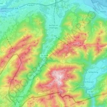
Aschau im Chiemgau topographic map
Interactive map
Click on the map to display elevation.
About this map
Name: Aschau im Chiemgau topographic map, elevation, terrain.
Average elevation: 957 m
Minimum elevation: 520 m
Maximum elevation: 1,787 m
Other topographic maps
Click on a map to view its topography, its elevation and its terrain.
Harras
Allemagne > Bavière > Landkreis Rosenheim > Prien am Chiemsee > Harras
Harras, Prien am Chiemsee, Landkreis Rosenheim, Bavière, 83209, Allemagne
Average elevation: 529 m
Bernau am Chiemsee
Allemagne > Bavière > Landkreis Rosenheim
Bernau am Chiemsee, Landkreis Rosenheim, Bavière, 83233, Allemagne
Average elevation: 639 m