
Thank you for supporting this site ❤️
Make a donation
Make a donation
Foz de Alge topographic map
Click on the map to display elevation.
Thank you for supporting this site ❤️
Make a donation
Make a donation
About this map
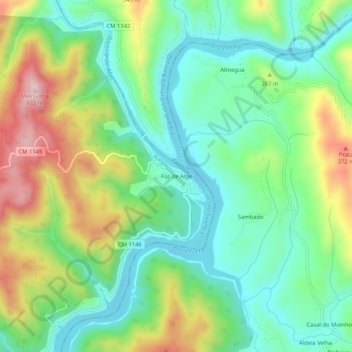
Name: Foz de Alge topographic map, elevation, terrain.
Location: Foz de Alge, Arega, Figueiró dos Vinhos, Leiria, Portugal (39.80795 -8.29603 39.84795 -8.25603)
Average elevation: 215 m
Minimum elevation: 104 m
Maximum elevation: 425 m
Thank you for supporting this site ❤️
Make a donation
Make a donation
Other topographic maps
Click on a map to view its topography, its elevation and its terrain.
Fragas de São Simão
Portugal > Leiria > Figueiró dos Vinhos > Aguda > Ponte de São Simão
Average elevation: 357 m
Thank you for supporting this site ❤️
Make a donation
Make a donation