Geolocate

Greyton topographic map

Interactive map

Click on the map to display elevation.

About this map

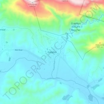
Name: Greyton topographic map, elevation, terrain.

Location: Greyton, Theewaterskloof Local Municipality, Western Cape, 7233, South Africa (-34.09075 19.56817 -34.01075 19.64817)

Average elevation: 414 m

Minimum elevation: 187 m

Maximum elevation: 1,443 m

Other topographic maps

Click on a map to view its topography, its elevation and its terrain.

Botrivier

South Africa > Western Cape > Theewaterskloof Local Municipality

Botrivier, Theewaterskloof Local Municipality, Western Cape, South Africa

Average elevation: 203 m

Riviersonderend

South Africa > Western Cape > Theewaterskloof Local Municipality > Riviersonderend

Riviersonderend, Theewaterskloof Local Municipality, Overberg District Municipality, Western Cape, 7250, South Africa

Average elevation: 212 m

Babilonstoring

South Africa > Western Cape > Theewaterskloof Local Municipality

Babilonstoring, Theewaterskloof Local Municipality, Overberg District Municipality, Western Cape, South Africa

Average elevation: 634 m