
San Pedro Pinula topographic map
Interactive map
Click on the map to display elevation.
About this map
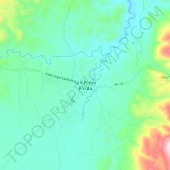
Name: San Pedro Pinula topographic map, elevation, terrain.
Location: San Pedro Pinula, Jalapa, Guatemala (14.62300 -89.88626 14.70300 -89.80626)
Average elevation: 1,152 m
Minimum elevation: 1,009 m
Maximum elevation: 1,690 m
Other topographic maps
Click on a map to view its topography, its elevation and its terrain.
Caserio Candelaria
Guatemala > Jalapa > San Pedro Pinula
Caserio Candelaria, San Pedro Pinula, Jalapa, Guatemala
Average elevation: 1,449 m