
Musselburgh topographic map
Interactive map
Click on the map to display elevation.
About this map
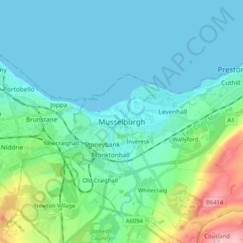
Name: Musselburgh topographic map, elevation, terrain.
Location: Musselburgh, East Lothian, Scotland, EH21 7DX, United Kingdom (55.90212 -3.09385 55.98212 -3.01385)
Average elevation: 32 m
Minimum elevation: 0 m
Maximum elevation: 172 m
Other topographic maps
Click on a map to view its topography, its elevation and its terrain.
Tranent
United Kingdom > Scotland > East Lothian
Tranent, East Lothian, Scotland, EH33 1AF, United Kingdom
Average elevation: 62 m
Ormiston
United Kingdom > Scotland > East Lothian > Ormiston
Ormiston, East Lothian, Scotland, EH35 5HN, United Kingdom
Average elevation: 102 m
Dunbar
United Kingdom > Scotland > East Lothian
Dunbar, East Lothian, Scotland, EH42 1ER, United Kingdom
Average elevation: 24 m