
Ambato topographic map
Interactive map
Click on the map to display elevation.
About this map
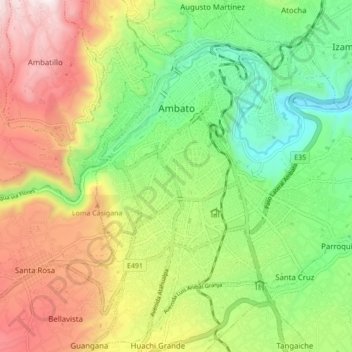
Name: Ambato topographic map, elevation, terrain.
Location: Ambato, Tungurahua, Ecuador (-1.30163 -78.65136 -1.21602 -78.56832)
Average elevation: 2,752 m
Minimum elevation: 2,345 m
Maximum elevation: 3,311 m
Ambato ist eine Stadt in Ecuador. Sie ist die Hauptstadt der Provinz Tungurahua, gelegen in einer Anden-Hochebene auf etwa 2570 m Höhe zwischen den Ost- und West-Kordilleren. Die Stadt liegt etwa 140 km südlich von Quito und 30 km nordöstlich des Chimborazo, des höchsten Berges des Landes. Durch die Stadt führt die Panamericana.