
Arvier topographic map
Interactive map
Click on the map to display elevation.
About this map
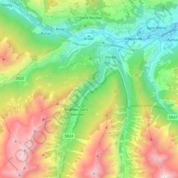
Name: Arvier topographic map, elevation, terrain.
Location: Arvier, Vallée d'Aoste, 11011, Italie (45.62988 7.02237 45.70957 7.18753)
Average elevation: 1,638 m
Minimum elevation: 610 m
Maximum elevation: 3,446 m
Other topographic maps
Click on a map to view its topography, its elevation and its terrain.
Planaval
Italie > Vallée d'Aoste > Arvier > Planaval
Planaval, Arvier, Vallée d'Aoste, Italie
Average elevation: 2,050 m