
Thank you for supporting this site ❤️
Make a donation
Make a donation
Rensselaer County topographic map
Click on the map to display elevation.
Thank you for supporting this site ❤️
Make a donation
Make a donation
About this map
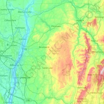
Name: Rensselaer County topographic map, elevation, terrain.
Location: Rensselaer County, New York, United States (42.46426 -73.78630 42.95865 -73.26485)
Average elevation: 239 m
Minimum elevation: -2 m
Maximum elevation: 981 m
Thank you for supporting this site ❤️
Make a donation
Make a donation
Other topographic maps
Click on a map to view its topography, its elevation and its terrain.
Pine Neck
United States > New York > Suffolk County > East Quogue > Town of Southampton
Average elevation: 4 m
Thank you for supporting this site ❤️
Make a donation
Make a donation
Mount Van Hoevenberg
United States > New York > Essex County > Town of North Elba
Average elevation: 677 m