
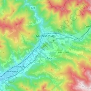
Mürzzuschlag topographic map
Interactive map
Click on the map to display elevation.
About this map
Name: Mürzzuschlag topographic map, elevation, terrain.
Average elevation: 979 m
Minimum elevation: 624 m
Maximum elevation: 1,665 m
Other topographic maps
Click on a map to view its topography, its elevation and its terrain.
Mixnitz
Autriche > Styrie > Bezirk Bruck-Mürzzuschlag
Mixnitz, Pernegg an der Mur, Bezirk Bruck-Mürzzuschlag, Styrie, 8131, Autriche
Average elevation: 680 m
Gemeinde Spital am Semmering
Autriche > Styrie > Bezirk Bruck-Mürzzuschlag
Gemeinde Spital am Semmering, Bezirk Bruck-Mürzzuschlag, Styrie, 8684, Autriche
Average elevation: 1,158 m
Bruck an der Mur
Autriche > Styrie > Bezirk Bruck-Mürzzuschlag
Bruck an der Mur, Bezirk Bruck-Mürzzuschlag, Styrie, 8600, Autriche
Average elevation: 827 m