
Thank you for supporting this site ❤️
Make a donation
Make a donation
Bernsen topographic map
Click on the map to display elevation.
Thank you for supporting this site ❤️
Make a donation
Make a donation
About this map
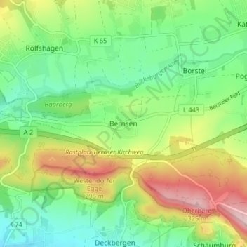
Name: Bernsen topographic map, elevation, terrain.
Average elevation: 164 m
Minimum elevation: 72 m
Maximum elevation: 323 m
Thank you for supporting this site ❤️
Make a donation
Make a donation
Other topographic maps
Click on a map to view its topography, its elevation and its terrain.
Bückeburg
Duitsland > Nedersaksen > Landkreis Schaumburg
Dit centrum is gesitueerd op de militaire vliegbasis van de stad. Deze draagt de naam Heeresflugplatz Bückeburg. Het militaire vliegveld heeft de ICAO-code ETHB. De geografische coördinaten luiden: 52° 16′ 43″ noorderbreedte en 9° 4′ 56″ oosterlengte. Het ligt op 70 m (230 ft) hoogte boven…
Average elevation: 71 m
Thank you for supporting this site ❤️
Make a donation
Make a donation