
Thank you for supporting this site ❤️
Make a donation
Make a donation
Canavoy topographic map
Click on the map to display elevation.
Thank you for supporting this site ❤️
Make a donation
Make a donation
About this map
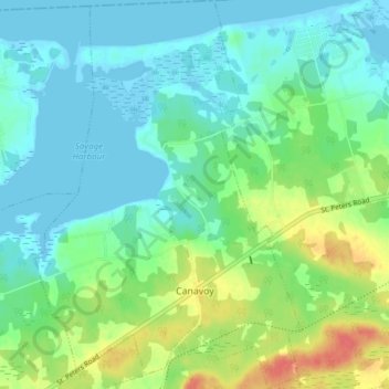
Name: Canavoy topographic map, elevation, terrain.
Location: Canavoy, Kings County, Prince Edward Island, Canada (46.38650 -62.84140 46.43910 -62.78906)
Average elevation: 15 m
Minimum elevation: -4 m
Maximum elevation: 50 m
Thank you for supporting this site ❤️
Make a donation
Make a donation
Other topographic maps
Click on a map to view its topography, its elevation and its terrain.
Prince Edward Island National Park
Canada > Prince Edward Island > Kings County > Greenwich
Average elevation: 2 m