
Emgwenya (Waterval Boven) topographic map
Interactive map
Click on the map to display elevation.
About this map
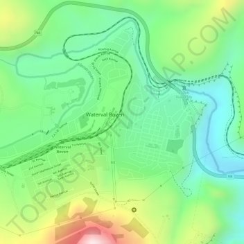
Name: Emgwenya (Waterval Boven) topographic map, elevation, terrain.
Average elevation: 1,424 m
Minimum elevation: 1,257 m
Maximum elevation: 1,712 m
Other topographic maps
Click on a map to view its topography, its elevation and its terrain.
eMakhazeni (Belfast)
South Africa > Mpumalanga > Nkangala > Emakhazeni Local Municipality
Average elevation: 1,890 m
Waterfall
South Africa > Mpumalanga > Nkangala > Emakhazeni Local Municipality > Emgwenya (Waterval Boven)
Average elevation: 1,422 m
Emakhazeni Ward 5
South Africa > Mpumalanga > Nkangala > Emakhazeni Local Municipality
Average elevation: 1,438 m
Emakhazeni Ward 2
South Africa > Mpumalanga > Nkangala > Emakhazeni Local Municipality
Average elevation: 1,648 m