
Aubange topographic map
Interactive map
Click on the map to display elevation.
About this map
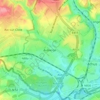
Name: Aubange topographic map, elevation, terrain.
Location: Aubange, Arlon, Luxembourg, Wallonie, 6790, Belgique (49.54720 5.78450 49.58720 5.82450)
Average elevation: 292 m
Minimum elevation: 258 m
Maximum elevation: 354 m
Other topographic maps
Click on a map to view its topography, its elevation and its terrain.
Athus
Belgique > Luxembourg > Arlon > Aubange
Athus, Aubange, Arlon, Luxembourg, Wallonie, 6791, Belgique
Average elevation: 304 m
Athus
Belgique > Luxembourg > Arlon > Aubange
Athus, Aubange, Arlon, Luxembourg, Wallonie, 6791, Belgique
Average elevation: 318 m