
Thank you for supporting this site ❤️
Make a donation
Make a donation
Prince County topographic map
Click on the map to display elevation.
Thank you for supporting this site ❤️
Make a donation
Make a donation
About this map
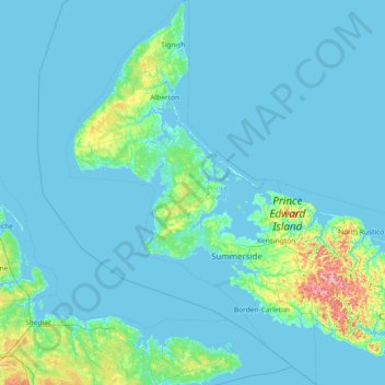
Name: Prince County topographic map, elevation, terrain.
Location: Prince County, Prince Edward Island, Canada (46.17432 -64.44602 47.06597 -63.49101)
Average elevation: 8 m
Minimum elevation: -3 m
Maximum elevation: 140 m
Thank you for supporting this site ❤️
Make a donation
Make a donation
Other topographic maps
Click on a map to view its topography, its elevation and its terrain.
French Village
Canada > Prince Edward Island > Queens County > Savage Harbour, Queen's County
Average elevation: 12 m
Thank you for supporting this site ❤️
Make a donation
Make a donation
Thank you for supporting this site ❤️
Make a donation
Make a donation
Thank you for supporting this site ❤️
Make a donation
Make a donation
Thank you for supporting this site ❤️
Make a donation
Make a donation
Prince Edward Island National Park
Canada > Prince Edward Island > Kings County > Greenwich
Average elevation: 2 m
Thank you for supporting this site ❤️
Make a donation
Make a donation