
Meithalun topographic map
Interactive map
Click on the map to display elevation.
About this map
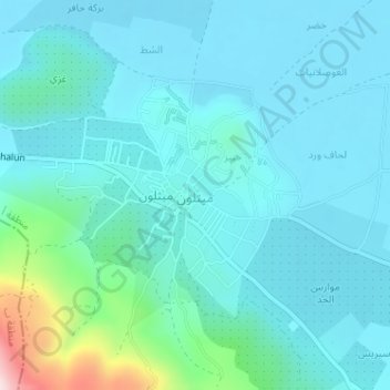
Name: Meithalun topographic map, elevation, terrain.
Location: Meithalun, Area A, West Bank, Palestinian Territory (32.33873 35.25775 32.35722 35.28243)
Average elevation: 403 m
Minimum elevation: 347 m
Maximum elevation: 736 m
The town is situated along the western edge of Marj Sanur, a valley and seasonal lake. It is the largest locality, of seven total, bordering Marj Sanur and controls the largest share of its fertile lands. It has an average elevation of 385 meters above sea level and is not elevated from its immediate surroundings. The total land area of Meithalun is 12,495 dunams. The old core of the town consists of 18 dunams. Khirbet Khaybar, to the northeast of the town, is part of Meithalun's jurisdiction. It has an elevation of 423 meters above sea level and consists of ruins, namely the remains of a wall, building foundations, a tomb and water tanks cut from stone.