
Lake of the Woods County topographic map
Interactive map
Click on the map to display elevation.
About this map
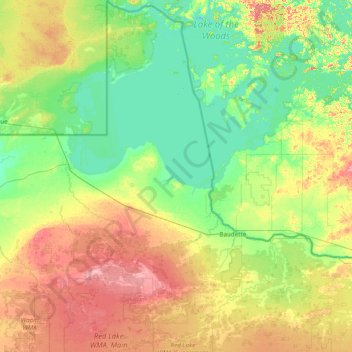
Name: Lake of the Woods County topographic map, elevation, terrain.
Location: Lake of the Woods County, Minnesota, USA (48.36906 -95.34261 49.38449 -94.43111)
Average elevation: 343 m
Minimum elevation: 317 m
Maximum elevation: 405 m
Other topographic maps
Click on a map to view its topography, its elevation and its terrain.
Cathedral Hill Park
USA > Minnesota > Saint Paul
Cathedral Hill Park, Saint Paul, Ramsey County, Minnesota, USA
Average elevation: 252 m
Keller Lake
Keller Lake, North Maplewood Drive, Maplewood, Ramsey County, Minnesota, 55109, USA
Average elevation: 272 m
Alexandria
USA > Minnesota > Alexandria
Alexandria, Douglas County, Minnesota, 56308, USA
Average elevation: 426 m
Prospect Park - East River Road
USA > Minnesota > Minneapolis
Prospect Park - East River Road, Minneapolis, Hennepin County, Minnesota, USA
Average elevation: 260 m