
Lorca topographic map
Interactive map
Click on the map to display elevation.
About this map
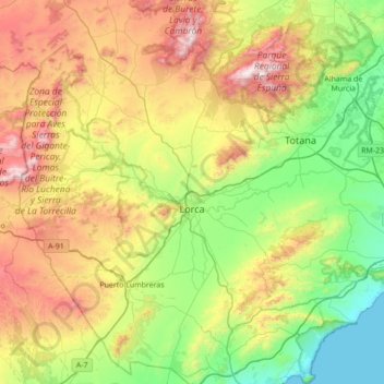
Name: Lorca topographic map, elevation, terrain.
Location: Lorca, Alto Guadalentín, Murcia, Spanje (37.42102 -2.01265 37.97018 -1.39668)
Average elevation: 537 m
Minimum elevation: -1 m
Maximum elevation: 1,561 m
Other topographic maps
Click on a map to view its topography, its elevation and its terrain.
Puerto Lumbreras
Spanje > Murcia > Alto Guadalentín
Puerto Lumbreras, Alto Guadalentín, Murcia, 30890, Spanje
Average elevation: 481 m